Geology, Geography, Weather
Geology
Geological history of Crete is very interesting. Some details I found in the book by George Sfikas Wild flowers of Crete. This history could be followed say about as fas as Tertiary. As Tertiary used to be considered a period between 67 and 1.8 mil. years ago, in which sea ammonites became extinct and also the extinction of great reptiles (so-called dinosaurs) was "successfully" got through (however, their main and in movies famed walk away from scene came into being already during the previous geological age - Mesozoic). In course of Tertiary, earlier periods Alpine folding passed, when extensive sea sheets escaped from Europe – roughly from its current middle and western parts. Weather which always persisted from Mesozoic was warm and wet (in that time the areas described were more closely to equator) and huge diversification of mammalian and avian species started. From sea aquatics, molluscan and cartilaginous fishes (mainly sharks) were the most widespread and in plant species the great progress of angiosperms started. Toward the end of this era the weather got colder step by step, and various islands appeared, continents obtained different shape and on poles, glaciers originated in which more and more amount of water is deposited which causes decrease of world ocean level. Not only in Europe and Mediterranean occurred continental drifts of earth's sheets and their declines and uplifts, and among others Aegean Periphery showed up. Spreading of land always continued in area of current Eastern Mediterranean which linked South-Eastern Europe with Asia Minor in that time. In Middle Miocene - one of the later periods of Paleogene (Earlier Tertiary) – about 18 mil. years ago - there were in Aegaean both high mountains and huge depressions which were filled by lakes of fresh water. In that time Crete was joined both with current continental Greece and with today's Turkey and Aegean islands, too - this all created almost entire continental bridge among Europe, Asia and Africa. Toward the end of Miocene this area was inhabited by great plants-eating mammals (hippos, elephants) which need for their surviving very large living space with abundant sources of vegetable food and enough water. The shape of Aegean started changing towards the end of Tertiary thus roughly 10 mil. years ago. Fall of land and abundant precipitation which occurred often suddenly though but persisted then for substantial time, led to the increasing of sea-level of Mediterranean Sea and to the subsequent partition of Aegean land. During this time Crete was divided into two or three smaller islands surrounded by the sea. Next continental uplifts occurred roughly 1 – 3 mil. years ago when continental desks drifted all the time. Geologic activity created very deep tectonic rift which originated open sea around Crete having almost the same shape like today. However, Crete wasn't one island in that time like it is known today but its fragmentation was persisting until the last geological period which is Quaternary. Towards to the end of Pleistocene (Quaternary) - about 1 mil. years ago - arrangement of Aegean Sea started evolving towards the shape strongly remindful today's status. Nevertheless, in the Aegean area entire sheets of land still persisted. One of them e.g. linked present Cyclades into one complex. Islands of Southern Aegean – Crete, Karpáthos, Kássos and Rhodos – were rather evidently off these land masses. During Pleistocene geological processes - mainly uplifts of land - ran as well. (approx. 1 mil. – 25 thousands years ago), however, they were much smaller rate. Despite it their role in fauna and flora developing was very important because as their results was the fact Crete was many times joined with neighbouring continents and with remains of Aegean (like Cyclades), too. For period of Quaternary there is characteristic changing of warm and colder seasons due to the temperature swings during glacial and interglacial periods. These deep climatic changes understandably influenced Cretan fauna and flora. But in could be said this effect was indirect. Namely, as glaciers (in which there were bound huge amount of water) spread from poles into mild climatic zone during glacial periods, it happened often gigantic fall of sea level which created temporary lend bridges connecting Crete with neighbouring lands resulting in colonization of the island by next plant and animal species. It is estimated that during the first three glacial periods – Günz, Mindel and Riss - sea level fall down often for hundreds meters!! For example within the glacial Riss only this fall was perhaps for 200 m!! Just during the last glacial stage – Würm – when glacier did not reach so far towards the south this fall was considerably lower – "only" for 90 m. The number of animal's and plant species which overcame land bridges, repeatedly created during glacial stages, and which settled down Crete was very remarkable. Survey of spreading of endemitic species has shown interesting findings which might support long-ago dividing of Crete on several smaller islands: the map on which some areas with the densest spreading of these species would be drawn, it noticeably overlaps with the map on which the shape of Crete in geological history during Pleistocene (2 - 1 mil. years ago, when it was compound from more smaller islands) would be drawn. Very interesting almost agreement!!!
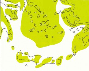
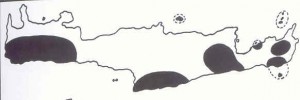
Interesting and almost conformal are these pictures!! The upper one shows fragmentation of former Crete and the lower one are recent areas of endemitic plants!!
(Iˇve dared to take over scanned pictures from the above-mentioned book in which there are also not authentic. They are created by publications of Greuzburg (about geological evolution) and Sven Snogerup (concerning endemics of Crete)
Geography; Weather
Crete is the 4th or 5th the largest island in Mediterranean. It is a part of huge underwater range spreading south-eastwards from Peloponéssos peninsula over Kithéra and Antikithéra islands. In the area of Crete this range turns eastward and then nord-eastward to reach Asia Minor coast southward from Turkish Bodrum, over islands of Karpáthos and Rhodos. The second such underwater mountain's range from which only the highest parts in shapes of islands can be seen stretchs a little bit northward, roughly from Athens and Euboia Island, and over Cyclads, Southern Sporades and Dodekasesse it gets to the coast of Asia Minor somewhere between Sámos Island and Turkish Bodrum. The whole area is tectonicly active although recently the straight tectonic activity can be observed near Théra Island (= Santorini) only.
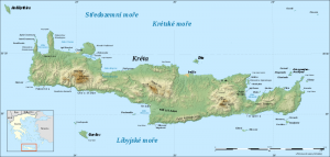
Size data very differ, for example the data from three sources - an older guide-book, Baedecker and the newest - Kletr-guide-book give different numbers differing for hundreds of square km within the range of 8250 to 8550 km2. The island is elongated in west-eastern direction it is approximately 260 km long and between 12 and 57 km wide.
About Crete it can be said it is the mountainous island with smaller exceptions. Rather large lowlands are along the northern coast and also along the southern one in the central part of the island with the altitude up to 300 m. Among single mountains massifs there are also considerably lower parts with altitude of uplands. Straight in mountains there are several "oropedio" thus mountain's or upland plains which are very fertile although they can lie in altitude even over one thousand meters (e.g. Omalos Plateau). However, most of them are at lower altitude. The most known are (from west to east) Omalos, Anopolis, Askifou, Niátos, Trikoukia, Lassithi, Nídha and other smaller. Towards the east elevation of mountain ranges gets lower. The wildest, westernmost and highest mountains (it's said with more than 20 summits over 2 thousands meters) are Levka Ori (White Mountains) which reaches (by the summit of Páchnes, the second the highest on Crete) altitude of 2453 m. These mountains fascinated me absolutely and this is the reason that the most information on this website is about them.
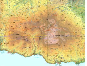
Levka Ori are roughly enclosed: on the east - by a valley of the Mouselas River and from its southern end by a connecting line among places of Asi Gonia, Kallikratis and Frangokastelo on the southern coast, on the south - by the Libyan Sea shore, on the west - by the gorge of Agia Irini running northward from the village of Sougia on the coast and this border reachsreachesr as the place called Seli on the main road to Chania, and on the north - Levka Ori are bordered by the line roughly among sites of Lakki, Meskla, Therisso, Drakona, Kambni, Kares, Madara, Alikambos and the lake and the village of Kournas. Still more to the east there is a wide area of lowlands and highlands with isolated mountains ranges which is terminated by the massif of Psiloritis (called Idi Mountains - Idi Ori, as well). The highest peak of this mountain is Psilorotis (as well Ida or Stavros) which is (with its altitude of 2456 m) the highest summit of the whole Crete Island. This mountain is formed by just one huge range furrowed by many wild gorges. This range stretches roughly from north-west toward south-east, and its length is about 40 km whereas its width is not more than 20 km. Southward to south-eastward the range falls down rather steeply into lowland of Méssara spreading around the huge river of Géropotamos, in return reverse direction the mountains gets lower gradually. Above mentioned lowland is separated from the sea by next mountain range of Asteroussia with maximum altitude up to 1200 m. East of Psiloritis massif, in wide belt approximately from the capital Iraklio as far the south coast there is also a zone of lowlands and low highlands which is on the east bordered again by rather large massif - Dikti Mountains (Diktí Ori). Inside this mountains there is enclosed the largest and probably the most known plateau of Crete – Lassithi. The highest summit of this range is Diktí Latzaros (2148 m). Farther eastward the country gets lower again into the narrowest place of Crete, a join approximately between places of Gournia and Ierapetra (the southernmost town of Europe) to come still once in the view some hills called Thriptís Ori a Ornó Oros – which reach maximum almost 1500 or almost 1200 m, respectively. Farther east of them elevation of terrain still gets lower (up to 200 m maximum) and extreme end of Crete (one would say the easternmost but because the island bands in its eastern part to the north, this island’s prong points to the north) is quite flat.
Largely dominant ground of mountains is limestone. Stable rivers are scantily in Crete and their streams are very changing: during summer season is often strongly reduced and smaller streams can dry up totally. There is also on Crete one fresh-water lake called Kournás lying between Chania and Rethymno cities in northern part of the island, not so far (several tens km only) from the shore.
Weather of Crete is just “easy”: transitional periods (spring and autumn) practically don’t exist in the shape which is known for example from Middle Europe. There is either “winter” season (but with temperature very rare falling under +5°C on the coast) or summer with temperatures often over + 30°C. Precipitations during winter season can be rather heavy (and Creteans say the worst weather is during March), whereas the summer months use to be entirely without rains. The wind which blows often from the north or north-west used to be unpleasant and among other mixes sea water which gets colder then common 25 – 27°C, in this way. Other strong wind, called “shirrokko” causes vice versa sudden lift of temperatures because it blows from the south, from Sahara. A various tables of average temperature everybody can find on internet.
For example here:
Comments
Overview of comments
https://www.hostboard.com/forums/f1605/1230889-%20car%20rental.html
(Jacquetta Hatmaker, 2019-01-03 21:50)
Hey, it's Jacquetta!
Pretty much everyone is using voice search with their Siri/Google/Alexa to ask for services and products in 2018, and next year, it'll be EVERYONE of your potential customers. Imagine what you are missing out on.
Just now, I can only find estranky.cz on text search after digging a few pages (that's BAD), businesses on top are earning all the traffic and business!
Fulfill all your clients' questions on your website and win their trust! Find out how easy it is : https://goo.gl/6h8hfW
Get your voice search optimized content: https://goo.gl/tQh8J7
Starts at $20, regular SEO content starts at $10
Cheers,
Jacquetta


dfytneLolo eLolo
(Kevincix, 2026-04-25 01:18)